Mapas

Taxonomía

Código

Nota(s) sobre el alcance

  • Refers to graphic or photogrammetric representations of the Earth's surface or a part of it, including physical features and political boundaries, where each point corresponds to a geographical or celestial position according to a definite scale or projection. The term may also refer to similar depictions of other planets, suns, other heavenly bodies, or areas of the heavens. Maps are typically depicted on a flat medium, such as on paper, a wall, or a computer screen. For similar depictions on a sphere, see "globes (cartographic spheres)."

Nota(s) sobre el origen

  • AAT

Mostrar nota(s)

Términos jerárquicos

Mapas

Términos equivalentes

Mapas

Términos asociados

Mapas

3 Descripción archivística resultados para Mapas

3 resultados directamente relacionados Excluir términos relacionados

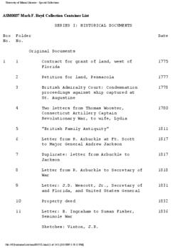
Sandra Riley and Peggy C. Hall collection

  • ASM0601
  • Colección
  • 1960-2016 (bulk)

This collection contains a collection of writings and research from local historian, playwright, director, and teacher, Sandra Riley, and poet, teacher, and musician, Peggy C. Hall. The materials currently include manuscripts, research notes, journals, interviews, drafts, playscripts, ephemera, poetry, and other materials pertaining to their life's work and writings.

Sin título

Simon Langlois collection

  • ASM0750
  • Colección
  • 1746-1872

This collection contains 20 maps and 10 prints in French, depicting locales and images from the Americas and the Caribbean during the 18th and 19th centuries.

Sin título

Mark F. Boyd collection

  • ASM0037
  • Colección
  • 1493-1953

The Mark F. Boyd Collection contains materials relating to Florida and United States history as well as to natural history and medicine.  The collection, arranged in six series, includes maps, newspapers, prints, photographs, pamphlets, original documents, copies of historical documents, reprints of articles and other materials.

Sin título