Historical maps

Taxonomy

Code

Scope note(s)

  • Refers to maps that indicate political administrative boundaries or other characteristics of a region at periods of time before the present. They typically include historical names for places, historical population dispositions, and the historical state of physical features.

Source note(s)

  • AAT

Display note(s)

Hierarchical terms

Historical maps

Equivalent terms

Historical maps

Associated terms

Historical maps

2 Archival description results for Historical maps

2 results directly related Exclude narrower terms

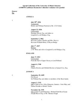
Caribbean Documents collection

  • ASM0570
  • Collection
  • 1542-1959

This collection includes various types of documents pertaining to the historical and cultural production taking place in the Caribbean. Materials include correspondence, diaries, ledgers, property transactions including slave registers, reports, typescripts, from the various islands of the Caribbean such as Antigua, the Dominican Republic, Haiti, Jamaica, Puerto Rico, St. Kitts, St. Christopher, Trinidad and Tobago from the 16th to the present. The collection is further enhanced by the acquisition of antique maps from cartographers such as Linschoten and Sanson.

Cuban Map Collection

  • CHC0468
  • Collection
  • 1500-2000

The Cuban Map Collection contains maps dating from the 16th century to the 21st century. The digital collection contains maps in the public domain dating from the colonial period to 1923 and includes general maps of the island, provincial maps, city and town maps, and other specialized map formats in a variety of scales, colors and artistic styles.