University of Miami: Pedestrian Bridge Proposal.
- Item
- 2014
Part of:
Pedestrian Bridge Proposal.
Arquitectonica
59 results with digital objects Show results with digital objects
University of Miami: Pedestrian Bridge Proposal.
Part of:
Pedestrian Bridge Proposal.
Arquitectonica
University of Miami: Whitten University Center Plaza.
Part of:
Whitten University Center Plaza. 02/23/2012.
Arquitectonica
University of Miami: Student Activities Center
Part of:
Student Activities Center interiors, Floor plans
Arquitectonica
Manual of architectural possibilities 004 : floods
Part of:
"MAP is a folded poster where information is immediate, dense and objective on one side, and architectural and subjective on the other. Map is a guide to potential actions in the built environment, a topography of ideas or a folded encyclopedia of the possible."
Cook, Peter, 1936-
University of Miami: Cox Science Center
Part of:
Site and content analysis. Framework of approach, plans.
Arquitectonica
Part of:
Limited edition to commemorate the coronation of Emperor Akihito
Kokudo Chiriin
Brickell Avenue Bridge Competition
Part of:
Site plan of a Brickell Avenue Bridge proposal showing cross-section with a short project description
Charles Deering Estate Restoration/Rehabilitation Plan and Feasibility Study
Part of:
This folder contains 7 pages of different blueprints of the Charles Deering Estate dated 03-31-1989.
Shepard Associates Architects & Planners Inc
University of Miami Coral Gables Campus : design manual
Part of:
Design manual for the Coral Gables campus presented to the University
University of Miami campus master plan : competition
Part of:
Campus design competition program and guidelines. Jury of prominent architects including Aldo Rossi.
University of Miami
Dade County Area Soil Survey Maps
Part of:
1 binder with 63 fold out approx. 11x24.5 overhead aerial photographs compiled into soil survey maps. A letter sized 1972 Dade County street map is used as the index. Each map has the same caption.
"This soil survey map was compiled by the U.S. Department of Agriculture, Soil Conservation Service, and cooperating agencies. Base maps are orthophotographs prepared by the U.S. Department of Interior, Geological Survey from 1985 aerial photography. Coordinate grid ticks and land division corners, if shown, are approximately positioned."
United States Department of Agriculture
Part of:
This guide is a co-production with the School of Architecture, Tulane University, New Orleans.
International Union of Architects
Part of:
Drawing with streets, houses and landmarks.
Timanus, Martha Dorn
Carrollton School (Alterations and Additions)
Part of:
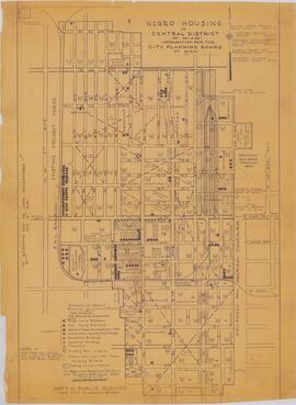
Negro Housing in Central District of Miami
Part of:
"Negro Housing in Central District of Miami
Information for the City Planning Board of Miami"
Plat map of what is today Overtown made for the City Planning Board. NW 21st Terrace to NW 6th Street and NW 7th Ave to NW 1st Ave. No date but mention of 1940 census.
City Planning Board of Miami
Pan American Center and Exposition Causeway Island
Part of:
Map of recommended cite on a MacArthur causeway island for a Pan American Center and Exposition
City Planning Board of Miami
Day Grove Terrace, Coconut Grove, Florida
Part of:
City certified street map of the neighborhood in Coconut Grove that included "Cornelia Drive," "Greenwood Road," "Grapeland Blvd. or Glades St.," and "Main St. or Tigertail Road." Certified by the engineer R. L. Stewart that is it based on his survey. Accepted by the City of Coconut Grove July 7, 1924.
Coconut Grove (Miami, Fla.)
Part of:
Part of:
Part of: